Tag: road trips

  • From Höfn to Húsavík: The Eastern Fjords and Mývatn

    From Höfn to Húsavík: The Eastern Fjords and Mývatn

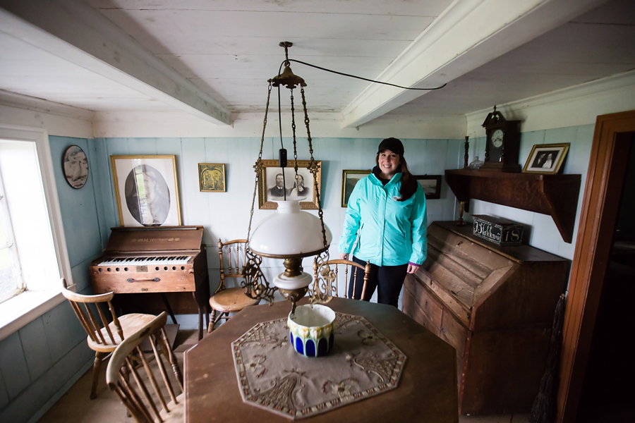
    So far on our road trip we were treated to an incredibly rich variety of landscapes including farmland, lava fields, glaciers, mountains, a black sand beach, and terrain that I can only describe as spongy moss-covered hills. On Ring Road Day Three, we spent the morning weaving in and out of the eastern fjords along the Atlantic, and in the afternoon, the mysterious landscape of Mývatn couldn’t have looked any more different than if we were actually on another planet. I’ll get to that, but first the east coast.

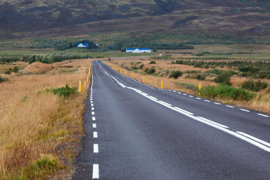
    This was the longest day of driving for us with over 400 km between our overnight stays in Höfn and Húsavík, so we didn’t get out to stop as much. Not as much just means every half hour or so instead of every ten minutes. Actually for the drive through the eastern fjords we mostly just enjoyed the view from the car, and what a gorgeous view indeed. You can also see from the photos below that we were gifted with perfect weather! I even had to wear my sunglasses that day.

    01_eastern_fjords_and_myvatn_2014_blog

    02_eastern_fjords_and_myvatn_2014_blog03_eastern_fjords_and_myvatn_2014_blog

    It did take several hours to trace along the edges of the fjords, so we stopped mid-day for lunch in a cute harbor town called Reyðarfjörður (population: 1102). And as I mentioned, in the interest of time we were really trying not to stop too often so that we would arrive at Mývatn with plenty of time to explore, but when I saw this waterfall shortly after lunch we had to stop. I didn’t feel like I had a truly solid waterfall photo that I loved at this point, and with the weather behaving so nicely I couldn’t pass up the opportunity to try a long exposure waterfall shot one more time! The photo below of the lower part of the falls is one of my favorite images from the trip. I have no idea what the name is (probably something “-foss” right?), but it’s somewhere between Reyðarfjörður and Dettifoss and easily spotted from the road if that helps. It’s a very picturesque little place, and one or two other cars pulled over to join us while we were checking it out.

    04_eastern_fjords_and_myvatn_2014_blog05_eastern_fjords_and_myvatn_2014_blog06_eastern_fjords_and_myvatn_2014_blog

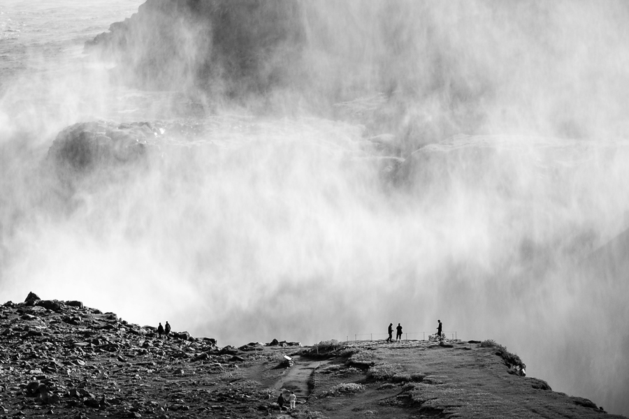
    Speaking of Dettifoss (or “dental floss” as Chris kept calling it), that was our next planned stop only we weren’t sure we’d be able to see it. Just days before our trip, Bárðarbunga showed signs of imminent eruption and the road to Dettifoss was closed as a precautionary measure. For that reason, I had mentally crossed the waterfall off of our list until we approached an open road with a sign pointing to Dettifoss! We figured if it wasn’t safe it wouldn’t be open, so we turned off Rt. 1 onto an unpaved very bumpy road and off we went to see the most powerful waterfall in Europe.

    08_eastern_fjords_and_myvatn_2014_blog

    Dettifoss might be the most powerful, and it is pretty, but it perhaps it’s not THE prettiest waterfall on account of the muddy water. The massive amount of midge flies in attendance didn’t help either. I do like the shot below that Chris took of the spray with a few people in silhouette. I think if we had been on the other side, there was probably enough sun to result in a rainbow over the falls, but we were short on time. We were glad to see Dettifoss, especially since it played a prominent roll in the opening scenes of Promethius (a movie that Chris enjoyed; I did not), but the amount of time it took to get there might not be worth it to everyone. I suppose it just matters how much time you have to spare. The road on Google Maps looks like it’s about 20 minutes, but because of the pothole-y-ness of the road, it took us about 45 minutes. We kept driving and driving and wondering where in the world the waterfall was and if we were even going the right way. So if you go, just know that it takes a while to get there and that it’s slow going even in an SUV, but a fun ride nonetheless!

    09_eastern_fjords_and_myvatn_2014_blog10_eastern_fjords_and_myvatn_2014_blog11_eastern_fjords_and_myvatn_2014_blog

    Once we were back on Rt. 1 after our dental floss Dettifoss visit, we immediately came across the road that leads from the north to Vatnajökull, the huge ice cap that sits on top of Bárðarbunga. F88 was definitely closed and is still closed at the time of writing this post. We spent some time there taking photos and I also used it as an opportunity to send some please-don’t-ash-up-the-sky vibes to Bárðarbunga.

    12_eastern_fjords_and_myvatn_2014_blog

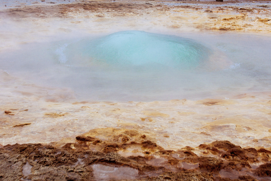
    As the day slowly transitioned into evening, the landscape changed as well albeit quite dramatically. We arrived in the Mývatn area around 7pm, but no matter – we still had plenty of sunlight thanks to the cooperative weather and clear skies. We smelled our first Mývatn-area stop well before we spotted it. The geothermal area of Námafjall Hverir provides a close-up view of steaming fumaroles and bubbling mud pots, as well as an olfactory experience I’ll never forget. The combination of a strong sulfur smell and the hoards of midge flies didn’t encourage us to stay very long, but I found the area incredibly fascinating and almost not-of-this-world. It was there that I felt like I was walking around on Mars! This spot is another must-see for anyone with a passion for geology.

    07_eastern_fjords_and_myvatn_2014_blog13_eastern_fjords_and_myvatn_2014_blog14_eastern_fjords_and_myvatn_2014_blog15_eastern_fjords_and_myvatn_2014_blog16_eastern_fjords_and_myvatn_2014_blog17_eastern_fjords_and_myvatn_2014_blog18_eastern_fjords_and_myvatn_2014_blog23_eastern_fjords_and_myvatn_2014_blog

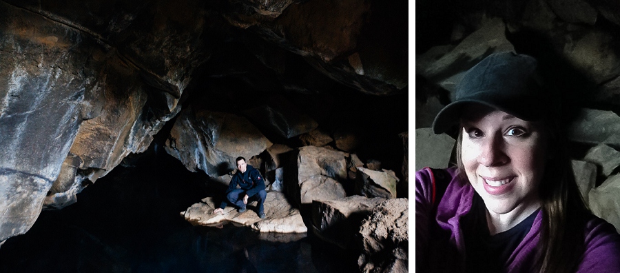
    The last stop of the day before hitting the hay in Húsavík was this dark hole that I actually climbed into if you can believe it. Do you recognize it, Game of Thrones fans? It’s Grjótagjá, the small lava cave that was used in the Jon Snow & Ygritte cave scene. If you watch the show, you know the one. The cave houses a geothermal hot spring and my original plan was to take a quick dip here for posterity, but the sign outside the cave indicated that visitors are not allowed to bathe in there, and I am typically a sign-obeying kind of tourist. That, and once I was inside I pretty much wanted to get out right away. As you can probably guess, I am not all that fond of sitting in small, dark, enclosed spaces. We spotted some discarded undies inside the cave, so we do know that some rule breakers were here!

    19_eastern_fjords_and_myvatn_2014_blog20_eastern_fjords_and_myvatn_2014_blog21_eastern_fjords_and_myvatn_2014_blog22_eastern_fjords_and_myvatn_2014_blog

    And just about twelve hours after our day on the road started, we ended it in Húsavík. The photo below was taken around 9pm with plenty of sunlight to spare! Gotta love those long daylight hours. Coming up: our fourth day on the road with a visit to Akureryi, nicknamed the Capital of North, and my first time ever horseback riding in Varmahlid!

    24_eastern_fjords_and_myvatn_2014_blog


  • Photo Friday – Aurora Borealis

    I haven’t gotten to this point in my Iceland adventure coverage yet, but I thought this image deserved its own post just because of the fun little story behind it.

    I took this photo on the night before our last road trip day. We stayed in Borgarnes, and I shot from the patio outside our hotel room. When I booked the trip, I didn’t have any expectation at all of being able to see the Northern Lights while we were in Iceland because they usually aren’t visible until at least September. But before we left the States, I read on a message board that the lights were visible as early as the week before our trip! So while I tried not to get my hopes up, I had also been following the forecast all week, and on Thursday night the Aurora Borealis forecast was marked as “moderate,” meaning there was a decent chance of seeing them. And as a bonus, our hotel was in a perfect dark area where we’d have very little light pollution to compete with the lights. When we checked in, I asked if I could please be placed on the wake-up call list for the Northern Lights and the concierge wrote my name down. Once we were in our room, I immediately set up my camera on the tripod and I dialed in a guess at what exposure settings might work (although I ended up changing them – this image was shot at ISO 200, f/2.0, with a shutter speed of 30 seconds).

    Chris and I went to sleep around 10:30pm hoping to either get a good night’s sleep OR get the call for the light show. As you can guess, it was the latter! When the phone rang at 1:30am I was SO EXCITED that I scraped my arm somewhere on the bed and had a weird wound on my elbow the rest of the week. I threw on some warm clothes and my shoes, and popped out the door to our patio. All of the rooms had their own exterior access (in addition to interior access), so that made it super easy to duck outside in the middle of the night. I was surprised to see that no one else was outside! It took a few minutes for my eyes to adjust, but once they did, I could see the lights and I started making images. Shorter exposures didn’t really seem to capture the vivid colors, so I ended up trying 30-second exposures and even longer. Unfortunately with the really long exposures, I have some tiny star trails that aren’t long enough to be interesting, and they’re just short enough to look blurry so the photos are just okay. But this image below is the one that worked out, and I’m happy to have it even though it meant I was very (very very) tired the next day. After the excitement of seeing the lights and taking pictures, I couldn’t fall asleep again until after 4am.

    I’d love to see the Northern Lights again someday (maybe in Norway or Sweden?) especially since I think this was a small/short show, but for now I can officially cross it off my bucket list!

    aurora_blog

  • Southern Iceland Sampler – Part II

    Southern Iceland Sampler – Part II

    Back to Ring Road Day Two! Our tour of Southern Iceland was one of the busiest days of the trip with the most planned stops, but to make it even more jam-packed we kept stopping the car (sometimes every 10 minutes) to try to capture the essence of Iceland. I’m not sure if it’s even possible with other-worldly landscapes like this.

    01_southern_iceland_pt2_2014_blog

    One of the spontaneous random stops along the road included this one at Laufskálavarða where we learned the real meaning of the rock stacks, or stone cairns, scattered throughout Iceland. After learning about the tradition, I topped one of the existing stacks with a pebble for good fortune.

    02_southern_iceland_pt2_2014_blog03_southern_iceland_pt2_2014_blog

    The next stop at Fjaðrárgljúfur canyon was one of our favorites of the day, although it’s hard to rank them with so many great sights to see! The canyon is just a short ride on an unpaved road off Rt. 1. I found excellent directions to the canyon online here. Fjaðrárgljúfur also shows up in Google Maps, so it’s pretty easy to find. We loved playing on the edges of the cliffs even though the signs told us to stay away from the edges. Just kidding, we didn’t go near any edges – only as close as seen in the photos below, and we were very careful. Also? Not a single drop of rain fell the whole time we were there! Which is great, because the ground was already soft and spongy, and we didn’t need it to be extra slippery with that big of a drop into the canyon.

    18_southern_iceland_pt2_2014_blog

    04_southern_iceland_pt2_2014_blog05_southern_iceland_pt2_2014_blog06_southern_iceland_pt2_2014_blog

    A while after we left the canyon, something magical happened – the skies cleared considerably! Expansive stretches of blue sky appeared nearly out of nowhere, and we were even casting a shadow with the car. We could finally see the entire horizon to confirm that there were indeed mountains out there. All over the place. They had been completely hidden for the first leg of our road trip!

    07_southern_iceland_pt2_2014_blog

    Our day wrapped up with a sunset over stunning Jökulsárlón, a glacial lagoon in Vatnajökull National Park. Did you hear that? A sunset! That means the sun stayed out and we still had a pretty clear sky. I was so thrilled you’d think I hadn’t seen sun for months. We were able to spend the entire time at the lagoon without any rain, which means lots of photos. And speaking of thrilled, you should have heard me when we approached the lagoon – I saw just a glimpse of it between hillsides and flipped out. It’s just so pretty! I was mesmerized by the textures and patterns in the ice to the point that I hardly took any photos. It was one of the many times I felt completely overwhelmed and immobilized by Iceland’s beauty. Using the wide-angle lens, I tried to take it all in with the landscape shots below, but I felt like I just couldn’t capture it all in an image. Chris took the amazing close-ups of the icebergs (I’m obsessed with the last black-and-white image of his) and he also took the photo of the cute little seal.

    08_southern_iceland_pt2_2014_blog09_southern_iceland_pt2_2014_blog10_southern_iceland_pt2_2014_blog11_southern_iceland_pt2_2014_blog15_southern_iceland_pt2_2014_blog12_southern_iceland_pt2_2014_blog13_southern_iceland_pt2_2014_blog14_southern_iceland_pt2_2014_blog16_southern_iceland_pt2_2014_blog17_southern_iceland_pt2_2014_blog

    We checked into our hotel pretty late that evening and didn’t eat dinner until almost 10pm, but it was worth the long day of amazing sights and photo opportunities. We crashed hard that night, and headed out the next morning for Day Three – the Eastern Fjords and the amazing landscape of Mývatn (seriously, it felt like we were on Mars). Stay tuned!

  • Southern Iceland Sampler – Part I

    Southern Iceland Sampler – Part I

    Not unlike Ring Road Day One, the weather on Day Two started out chilly and wet so we bundled up again and sported our waterproof outer-layers as we set out to explore Southern Iceland. Also similar to the first day on the road, our scheduled activity (glacier hiking) was thwarted by the weather, but we had plenty of other sights we planned to see rain or shine. In fact, there were so many things we squeezed into Day Two that I had to split the blog post into two parts.

    We knew to expect some dreary weather, but I admit I pouted a little bit upon waking up to a third gray day in Iceland. I suppose it was good to practice dreary-weather photography though. Sometimes it’s hard to take interesting photos when the light is completely flat and the sky adds no interest. Again, the clouds hung so low that we often couldn’t see the mountains in the background, but occasionally it added an interesting eerie effect. And this is the day that we started to see more farm animals, so of course I was excited about that!

    01_southern_iceland_pt1_2014_blog02_southern_iceland_pt1_2014_blog

    Our first stop brought us to a waterfall called Seljalandsfoss (so fun to say) fairly early in the morning, or at least early by my standards. We did beat the majority of the crowds by arriving just after 9am, but there were plenty of other photogs already there and several more were arriving with tripods in tow eager to capture the magic of the waterfall. I set up in an empty spot near a small footbridge and soon after extending my tripod legs I was joined by several other shutterbugs. I was especially excited to try out my new neutral density filter that would allow for long exposures resulting in that creamy blurred water look. I need some more practice, but I like the results! Oh, and a tip if you’re planning to visit and take photos – bring a lens cloth. Even in good weather you’ll need it to wipe mist from your lens every few minutes or so.

    03_southern_iceland_pt1_2014_blog04_southern_iceland_pt1_2014_blog05_southern_iceland_pt1_2014_blog

    We left Seljalandsfoss after the combination of spray from the falls and rain from the sky proved to be a little more water than I wanted on me or my camera. (I brought my camera’s Storm Jacket, but in my excitement to photograph the waterfall I forgot to take it with me.) On the way to our next spot we passed Eyjafjallajökull, but we couldn’t really see it because of the cloud cover. Am I starting to sound like a broken record yet? I can’t be mad at Iceland though – it’s gorgeous in even the ickiest weather.

    06_southern_iceland_pt1_2014_blog

    Next up, we popped by Skógafoss, but I won’t show you the image I took of the waterfall because it was still raining (the theme of our first few days) and I didn’t even get out of the car to snap the photo. Tsk, tsk – what a lazy fair weather photographer. In an attempt to get out of the rain, we decided to duck into the Skógar Folk Museum which turned out to be really interesting and cute so I’m glad we checked it out.

    07_southern_iceland_pt1_2014_blog

    Thankfully it stopped raining while we were inside, because a big portion of the museum is outside where visitors have the opportunity to tour the interior of actual turf houses and buildings that were moved from various settlements and reconstructed on the museum property. The photos of Chris and me standing inside the teeny dining room in one of the houses crack me up. We also saw elf houses! But no elves. Maybe they weren’t home.

    08_southern_iceland_pt1_2014_blog09_southern_iceland_pt1_2014_blog10_southern_iceland_pt1_2014_blog11_southern_iceland_pt1_2014_blog

    We decided to take advantage of the stoppage in precipitation to head to the beach! Only about 6km off of Rt. 1 just south of Vík is the Reynisfjara black sand beach where you can see some fascinating basalt column formations formed in the side of Reynisfjall mountain. I had seen photos online while planning our trip so this site was flagged in my notes as a must-see. Whether you’re into geology or not, the mountain is really impressive and the beach is beautiful so I highly recommend a visit. During the spring and summer, I think it’s also an area where you can spot Puffins (we were there after Puffin season). As a bonus, we were starting to lose the hoards of tour buses at this point on the Ring Road. This is a fairly well-known spot, but not as popular as others so the crowd was definitely thinner here.

    19_southern_iceland_pt1_2014_blog

    18_southern_iceland_pt1_2014_blog

    When we arrived, the temperature finally felt a little warmer and we were treated to a peek of blue skies. Just a sliver, but we were buoyed by the hint of nicer weather. I was even able to put my hood down! Out of all the places we planned to see, Reynisfjara was the spot where I wanted a photo of myself. I tried a selfie, but it didn’t capture the big picture of the basalt structures, so Chris took a portrait of me sitting on the columns and it’s one of my favorite photos of myself from the trip. I love the geometric pattern of the basalt, and it’s just not something we get to see every day.

    16_southern_iceland_pt1_2014_blog12_southern_iceland_pt1_2014_blog13_southern_iceland_pt1_2014_blog14_southern_iceland_pt1_2014_blog15_southern_iceland_pt1_2014_blog

    Our schedule was so jam-packed that day that we barely had time to stop for lunch, but we did manage to pop into a small grocery store in Vík to make a picnic lunch before heading to the spots next on our list – Fjaðrárgljúfur canyon and Jökulsárlón lagoon. More photos and stories coming up!

  • Driving in Circles: The Ring Road and the Golden Circle

    Driving in Circles: The Ring Road and the Golden Circle

    On our second day in Iceland, Chris and I picked up a rental car and kicked off our Ring Road adventure. Highway 1 goes all the way around the island in a complete circle, also known as the Ring Road, and it passes through or near many of the major must-see items in Iceland. The total length is over 800 miles, but Chris and I added several mini trips off the main route to see some off-the-beaten-path areas and we ended up adding about 400 miles to that total. Throughout my Iceland blog post series, I’ll point out which places are detours off the Ring Road. I’ll also be writing a Ring Road tips and logistics post to share some of the things we learned (the hard way).

    01_golden_circle_iceland_2014_blogmap and flag photos courtesy of tour.is 03_golden_circle_iceland_2014_blog02_golden_circle_iceland_2014_blog

    17_golden_circle_iceland_2014_blog

    We drove the Ring Road in a counter-clockwise direction, so Day One started off with the classic Golden Circle route just outside of Reykjavik. Not to be confused with the Ring Road, the Golden Circle consists of three major sites – Þingvellir National Park, Haukadalur valley (home to Geysir and Strokkur), and Gullfoss waterfall. The Golden Circle is one of the most popular attractions in Iceland and it’s easily accessed right from Reykjavik as a day trip. There are tons of tour companies who take groups out on Golden Circle tours, but I highly recommend the self-drive option. It’s very easy to drive in Iceland, and that way you can see the places at your own pace.

    Our first day on the road started off gray and quite cold, and then it quickly turned into a steady drizzle of rain. That weather would normally call for staying curled up under a warm blanket with hot tea and a good book or movie, but our adventure awaited so off we went! I think we might have missed out on some scenery because of the low hanging clouds (we kept wondering if there were mountains out there), but we were able to see most of what we set out to experience starting with parts of Þingvellir.

    One of my favorite sights was this field of rocks stacked in neat little piles in Þingvellir. Yep, piles of rocks. Sounds exciting, right? On the drive from Keflavik airport to Reykjavik, I noticed random stacks of rocks every once in a while in the lava fields along the highway, but I wasn’t exactly sure what I was seeing. When we arrived to this field in Þingvellir, the signage didn’t explain the stacked rocks, so (this is embarrassing to admit) I assumed it was a natural occurrence. I was fascinated! How did these piles of rocks stack themselves all over Iceland?! Spoiler alert: it’s not a natural phenomenon; the piles are man-made. The story is really cool though – over a thousand years ago, there was a farm destroyed by the first recorded eruption of the volcano Katla. Icelanders memorialized the tragedy by leaving a stone for good luck when they pass the farm. (We saw the original site later in our trip.) The tradition has continued, and I think I like that even better than if it were a natural occurrence.

    04_golden_circle_iceland_2014_blog05_golden_circle_iceland_2014_blog06_golden_circle_iceland_2014_blog

    We didn’t spend much time exploring Þingvellir because I had booked a snowmobiling trip scheduled to meet near the Gullfoss waterfall at Noon. Unfortunately, when we arrived at the meeting spot, the guide determined that it was too windy on the glacier to even stand up, so the excursion was canceled. We weren’t that disappointed because the weather would have made the ride pretty unbearable. So after lunch at the Gullfoss Cafe, we went to see Gullfoss, one of the most famous spots in Iceland.

    I’m sad to say that we didn’t take that many photos of Gullfoss because it was just too cold, rainy, and windy even with wearing lots of layers and a waterproof jacket. We definitely weren’t treated to the clear blue skies and rainbow often seen in photos of this double-drop waterfall, but it was beautiful and I’m glad we got to see it despite the weather. (Don’t mistake the blue in the sky for lovely weather – it’s really just dark, stormy clouds.)

    07_golden_circle_iceland_2014_blog08_golden_circle_iceland_2014_blog

    Our third and favorite stop in the Golden Circle was the geothermal activity of Haukadalur where we found hot springs, mud pots, and geysers. About five kilometers away, we could see the geyser erupting high into the air and I shrieked! (It’s a good thing Chris is used to me being over-excited about everything, or else I would have startled him into a car wreck.) As we entered the area, we saw steam rising from the ground and streams of steamy water running alongside the road. Before we saw the signs warning us not to, we did test the water temperature with our fingers. I can confirm that it is scalding hot! Ouch!

    09_golden_circle_iceland_2014_blog10_golden_circle_iceland_2014_blog11_golden_circle_iceland_2014_blog

    All of the sites on the Golden Circle route were pretty well mobbed with tourists, but photographing the geysers without people in the background proved to be an impossible task, so I just embraced it to show the popularity of the area. Capturing the eruption of Strokkur against a gray sky was also tricky, so I’m not sure you’ll get the full magnificence of the geyser. Strokkur erupts reliably about every 5-10 minutes at an impressive 15-20 meters high. You’ll just have to go see it in person! Chris took the gorgeous photo of the blue bubble just before eruption.

    12_golden_circle_iceland_2014_blog13_golden_circle_iceland_2014_blog14_golden_circle_iceland_2014_blog

    And in the spirit of full disclosure, I’ll mention that this next photo was not altered in Photoshop – the water in this hot spring really was that blue! In addition to squealing with delight over piles of rocks, steamy hot streams, geysers, waterfalls, not-of-this-planet landscapes, I also squealed over how blue this water was. I mean, why is it so blue?!

    15_golden_circle_iceland_2014_blog

    After seeing the main parts of the Golden Circle, there are a few options for driving back to Reykjavik if you are on a day trip. Chris and I, however, were headed towards South Iceland so we continued on Rt. 1 for an overnight stay in Hella. Up next, our busy Day Two exploring sights of the south and some of our favorites from the whole trip including Seljalandsfoss waterfall, Reynisfjara beach, Fjaðrárgljúfur canyon, and Jökulsárlón lagoon.

    16_golden_circle_iceland_2014_blog